- Midsund
-
Midsund kommune — Municipality — 
Coat of arms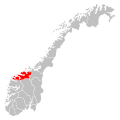
Møre og Romsdal within
NorwayMidsund within Møre og Romsdal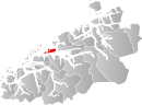
Coordinates: 62°42′31″N 6°47′48″E / 62.70861°N 6.79667°ECoordinates: 62°42′31″N 6°47′48″E / 62.70861°N 6.79667°E Country Norway County Møre og Romsdal District Romsdal Administrative centre Midsund Government - Mayor (2003) Helge Orten (H) Area - Total 94.75 km2 (36.6 sq mi) - Land 93.99 km2 (36.3 sq mi) - Water 0.76 km2 (0.3 sq mi) Area rank 390 in Norway Population (2010) - Total 1,952 - Rank 339 in Norway - Density 20.8/km2 (53.9/sq mi) - Change (10 years) -1.3 % Demonym Midsunding
Midsundværing[1]Time zone CET (UTC+1) - Summer (DST) CEST (UTC+2) ISO 3166 code NO-1545 Official language form Nynorsk Website midsund.kommune.no Data from Statistics Norway Midsund is a municipality in Møre og Romsdal county, Norway. It is part of the Romsdal region. The administrative centre is the village of Midsund on Otrøya island. The municipality consists of the islands of Otrøya, Midøya, Dryna, and the smaller (<1 km) islands of Magerøya and Tautra. The islands all sit at the mouth of the great Romsdalsfjord.
Contents
General information
The municipality of Midsund was established on 1 January 1965 when the old municipality of Sør-Aukra (population: 1,912) was merged together with part of Midøya island and the neighboring island of Dryna (population: 334) which were part of Vatne municipality.[2]
Name
The municipality is named after the strait that flows between the islands of Otrøya and Midøy, the Midsundet (Old Norse: Miðjusund). The first element of the name Miðja means "middle" and the second element sund means "strait" or "sound".[3]
Coat-of-arms
The coat-of-arms is from modern times. They were granted on 15 May 1987. The arms show two silver triangles on a blue background, representing Otrøya and Midøya islands in the ocean. These two main islands in the municipality are separated by a small strait, the Midsund. The geographical situation is symbolised in the arms.[4]
Churches
The Church of Norway has one parish with two churches within the municipality of Midsund. It is part of the Diocese of Møre and the Molde domprosti (Deanery).
Churches in Midsund Parish
(Sokn)Church Name Year Built Location
of the ChurchMidsund Otrøya kyrkje 1878 Uglvik, Otrøya Nord-Heggdal kapell 1974 Nord-Heggdal Geography
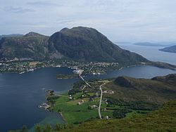 The village of Midsund seen from the opposite shore of the small strait that separates the islands Otrøya (far side) and Midøya.
The islands are separated from the mainland by the 3 kilometres (1.9 mi) wide Moldefjord. To the north the open sea begins, although the smaller (yet populated) islands of Harøya and Fjørtofta are even further out. These islands are part of the communities of Sandøy and Haram and are about 5 kilometres (3.1 mi) away from Otrøya.
The three largest islands of the community lie in a line from ENE to WSW (Otrøya, Midøya, and Dryna). Magerøy is between Midøy and Otrøy, a bridge connects it to the latter. Tautra lies in the Moldefjord. Otrøya is the main island of the community, measuring about 20 kilometres (12 mi) from east to west. The southern coast of Otrøya, Midøya, and Dryna rises from the fjord as sheer 800-metre (2,600 ft) tall cliffs. At Oppstad, the cliff is feared to collapse, which would cause a small tsunami in the Moldefjord.
On the southcoast of Otrøya the following small villages can be found: (from east to west) Solholmen, Nord-Heggdal, Oppstad, Sør-Heggdal, and Klauset. The north has the following villages: (east to west) Ræstad, Rakvåg, Tangen, Raknes, and Uglvik. On the western side of Otrøya, facing the bay that separates it from Midøya, lies the village of Midsund, the largest settlement in the community. The Midsund Bridge connects it with Midøya. Dryna and Midøya are also connected with a bridge. Ferries run between the islands and the mainland, they go across the Julsund to Molde (from Solholmen) and Brattvåg (from Dryna). The larger three islands' interior is wilderness, but the rims are used for keeping cattle and small farming.
Demographics
The community has 1,939 inhabitants (January 2005), with 50.3% male. The percentage of people older than 67 is 18.3%. Unemployment is 2.3%. Population growth is stable. Most inhabitants are fishers or small farmers.
References
- ^ "Personnemningar til stadnamn i Noreg" (in Norwegian). Språkrådet. http://www.sprakrad.no/nb-no/Sprakhjelp/Rettskrivning_Ordboeker/Innbyggjarnamn/.
- ^ Jukvam, Dag (1999). "Historisk oversikt over endringer i kommune- og fylkesinndelingen" (in Norwegian). Statistisk sentralbyrå. http://www.ssb.no/emner/00/90/rapp_9913/rapp_9913.pdf.
- ^ Rygh, Oluf (1908) (in Norwegian). Norske gaardnavne: Romsdals amt (13 ed.). Kristiania, Norge: W. C. Fabritius & sønners bogtrikkeri. pp. 307. http://books.google.com/books?id=yGtBAAAAIAAJ.
- ^ Norske Kommunevåpen (1990). "Nye kommunevåbener i Norden". http://www.ngw.nl/int/nor/m/midsund.htm. Retrieved 19 October 2008.
Municipalities of Møre og Romsdal Ålesund · Aukra · Aure · Averøy · Eide · Fræna · Giske · Gjemnes · Halsa · Haram · Hareid · Herøy · Kristiansund · Midsund · Molde · Nesset · Norddal · Ørskog · Ørsta · Rauma · Rindal · Sande · Sandøy · Skodje · Smøla · Stordal · Stranda · Sula · Sunndal · Surnadal · Sykkylven · Tingvoll · Ulstein · Vanylven · Vestnes · VoldaCategories:- Midsund
- Municipalities of Møre og Romsdal
- Villages in Møre og Romsdal


Wikimedia Foundation. 2010.