- Chanarambie Township, Murray County, Minnesota
-
Chanarambie Township, Minnesota — Township — Location within the state of Minnesota
 Chanarambie Township, Minnesota
Coordinates: 43°59′13″N 95°59′44″W / 43.98694°N 95.99556°WCoordinates: 43°59′13″N 95°59′44″W / 43.98694°N 95.99556°W Country United States State Minnesota County Murray Area – Total 35.5 sq mi (92.0 km2) – Land 35.5 sq mi (92.0 km2) – Water 0.0 sq mi (0.0 km2) Elevation 1,745 ft (532 m) Population (2000) – Total 223 – Density 6.3/sq mi (2.4/km2) Time zone Central (CST) (UTC-6) – Summer (DST) CDT (UTC-5) FIPS code 27-10882[1] GNIS feature ID 0663780[2] Chanarambie Township is a township in Murray County, Minnesota, United States. The population was 223 at the 2000 census.
Contents
Geography
According to the United States Census Bureau, the township has a total area of 35.5 square miles (92 km2), all of it land. Buffalo Ridge, the highest point in the county and the third highest in Minnesota, runs through the township.[3] Lake Wilson lies just east of this ridge.
Demographics
As of the census[1] of 2000, there were 223 people, 76 households, and 63 families residing in the township. The population density was 6.3 people per square mile (2.4/km²). There were 79 housing units at an average density of 2.2/sq mi (0.9/km²). The racial makeup of the township was 97.31% White, 0.45% Asian, 0.45% from other races, and 1.79% from two or more races. Hispanic or Latino of any race were 4.04% of the population.
There were 76 households out of which 38.2% had children under the age of 18 living with them, 75.0% were married couples living together, 5.3% had a female householder with no husband present, and 17.1% were non-families. 15.8% of all households were made up of individuals and 3.9% had someone living alone who was 65 years of age or older. The average household size was 2.93 and the average family size was 3.29.
In the township the population was spread out with 30.9% under the age of 18, 8.5% from 18 to 24, 26.0% from 25 to 44, 22.4% from 45 to 64, and 12.1% who were 65 years of age or older. The median age was 36 years. For every 100 females there were 116.5 males. For every 100 females age 18 and over, there were 116.9 males.
The median income for a household in the township was $31,875, and the median income for a family was $34,464. Males had a median income of $22,115 versus $16,250 for females. The per capita income for the township was $11,696. About 7.3% of families and 11.2% of the population were below the poverty line, including 16.0% of those under the age of eighteen and 10.3% of those sixty five or over.
Politics
Chanarambie Township is located in Minnesota's 1st congressional district, represented by Mankato educator Tim Walz, a Democrat. At the state level, Chanarambie Township is located in Senate District 22, represented by Republican Doug Magnus, and in House District 22A, represented by Republican Joe Schomacker.
References
- ^ a b "American FactFinder". United States Census Bureau. http://factfinder.census.gov. Retrieved 2008-01-31.
- ^ "US Board on Geographic Names". United States Geological Survey. 2007-10-25. http://geonames.usgs.gov. Retrieved 2008-01-31.
- ^ Murray County, Minnesota - Chanarambie, http://www.murray-countymn.com/php/index.php?option=com_content&task=view&id=56&Itemid=106, retrieved 2009-08-13
Municipalities and communities of Murray County, Minnesota Cities 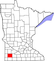
Townships CDP Unincorporated
communitiesLime Creek | Wirock
Categories:- Townships in Murray County, Minnesota


Wikimedia Foundation. 2010.