Målselva

Målselva
Målselva

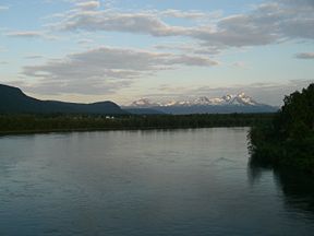
View of the Målselva river
Origin Lille Rostavatn
Mouth Malangen fjord
Basin countries Norway
Length 140 km (87 mi)
Source elevation 102 m (335 ft)
Mouth elevation 0 m (0 ft)
Basin area 6,144 km2 (2,372 sq mi)

The Målselva river in Troms county, Norway has given name to Målselv municipality and the Målselvdalen valley. The river empties into the in Målselvfjorden, an arm of the Malangen fjord, north of Olsborg. The rivers Divielva, Tamokelva, and Rostaelva converge near the Lille Rostavatn lake to form the Målselva. Later, the river Barduelva joins it. The river drains a watershed of 6,144 square kilometres (2,372 sq mi).[1] The Målselva river passes by the main villages of Bardufoss, Andselv, Øverbygd, and Skjold.

References

  1. ^ Store norske leksikon. "Målselva" (in Norwegian). http://www.snl.no/M%C3%A5lselva. Retrieved 2010-04-09. 

External links

Coordinates: 69°14′N 18°30′E / 69.233°N 18.5°E / 69.233; 18.5


Wikimedia Foundation. 2010.

Игры ⚽ Поможем решить контрольную работу

Look at other dictionaries:

  • Målselva — Verlauf der Målselva im Gebiet der Kommune Målselv Daten …   Deutsch Wikipedia

  • Målselv — kommune   Municipality   Coat of arms …   Wikipedia

  • Barduelva — Álddesjohka Verlauf der Barduelva im Gebiet der Kommune Bardu Daten …   Deutsch Wikipedia

  • Молсэльва — норв. Målselva Вид на ре …   Википедия

  • Målselvdalen — View of Målselva valley Location Målselv, Troms, Norway …   Wikipedia

  • Altevatnet — Bild gesucht  BW …   Deutsch Wikipedia

  • List of rivers of Europe — These are the main rivers of Europe (ecologically, the extreme west of the Palearctic ecozone which includes Russia in the east). See each article for their tributaries, drainage areas, etc.The longest rivers of Europe are: *Volga (3,692 km/2,294 …   Wikipedia

  • Troms — Infobox Fylke name = Troms alt names last = Romssa fylka idnumber = 19 capital = Tromsø governor = Svein Ludvigsen governor date = 2006 governor party = Høyre mayor = Terje Olsen mayor date = 2007 mayor party = Høyre region = Nord Norge arearank …   Wikipedia

  • Malangen — herred   Former Municipality   Malangen Coordinates …   Wikipedia

  • Altevatnet — Infobox lake lake name = Altevatnet image lake = caption lake = image bathymetry = caption bathymetry = location = Troms, Norway coords = coord|68|29|39|N|19|42|49|E|type:waterbody region:NO|display=inline,title type = inflow = outflow =… …   Wikipedia

Share the article and excerpts

Direct link
Do a right-click on the link above
and select “Copy Link”