- Mounds State Park
-
Mounds State Park
 Circular "Great Mound" at Mounds State Park

Location: Anderson, Indiana Coordinates: 40°8′0″N 85°40′53″W / 40.133333°N 85.68139°WCoordinates: 40°8′0″N 85°40′53″W / 40.133333°N 85.68139°W Governing body: Indiana DNR NRHP Reference#: 73000022 [1] Added to NRHP: 1973 Mounds State Park is a state park in Anderson, Indiana, featuring Native American heritage, and 10 ceremonial mounds built by the prehistoric Adena culture indigenous peoples of eastern North America, and also used centuries by later Hopewell culture inhabitants.
Contents
Mounds
The largest earthwork, the "Great Mound", is believed to have been constructed around 160 BCE. The Great Mound is a circular earth enclosure with an internal ditch and south to southwest entrance. The earthworks measure 394 feet (120 m) across from bank to bank. The 9-foot-tall (2.7 m) embankment is 63 feet (19 m) wide at its base, and the ditch is 10.5 feet (3.2 m) deep and 60 feet (18 m) across at its top. The central platform is 138 feet (42 m) across and was occupied by a 4-foot-high (1.2 m) central mound 30 feet (9.1 m) in diameter.
Popular culture
In 1900, a series of strange misshapen skeletons were unearthed from similar mounds in nearby Alexandria, Indiana. This brought thousands of tourists from around the Mid-West. In 1910, several locals admitted to stealing chimpanzee skeletons from the nearby Muncie Zoo's monkey house. In 1915 the skeletons were sold to a local museum which burned down in 1919.[2]
Canoeing is also available in Mounds State Park, on the White River.
See also
- Adena culture
- Hopewell tradition
- List of Hopewell sites
- List of burial mounds in the United States
References
- ^ "National Register Information System". National Register of Historic Places. National Park Service. 2007-08-31. http://nrhp.focus.nps.gov/natreg/docs/All_Data.html.
- ^ Werner, Nicholas (1937). Mysterious Circumstances Of Central Indiana. Clayton Books. pp. 121. ISBN 0-9137327-0-9.
External links
- Official Mounds State Park website
- Friends of Mounds State Park website
- Central States Archaeological Societies: Mounds State Park
- National Register of Historic Places for Madison County, Indiana
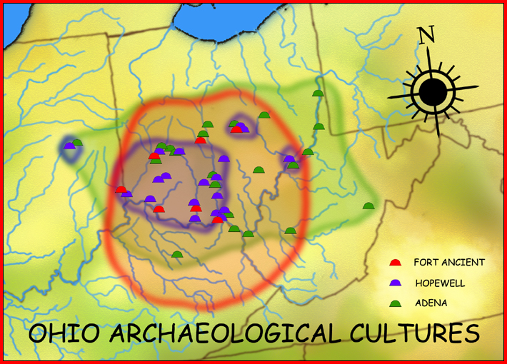
List of Adena culture sites · Woodland period · Mound builder (people) · List of archaeological periods (North America) Ohio Sites Adena Mound · Austin Brown Mound · Arledge Mounds I and II · Beam Farm · Clemmons Mound · Conrad Mound Archeological Site · Coon Hunters Mound · George Deffenbaugh Mound · Enon Mound · Fortner Mounds · Great Mound · Highbanks Metropolitan Park Mounds I and II · Hillside Haven Mound · Hodgen's Cemetery Mound · Horn Mound · Hurley Mound · Jackson Mound · Karshner Mound · Kinzer Mound · Luthor List Mound · Miamisburg Mound · Odd Fellows' Cemetery Mound · Old Maid's Orchard Mound · Orators Mound · Carl Potter Mound · Reeves Mound · D.S. Rose Mound · Ross Trails Adena Circle · Short Woods Park Mound · Snead Mound · Spruce Run Earthworks · David Stitt Mound · Story Mound (Cincinnati) · Story Mound (Chillicothe) · Wolf Plains Group · Zaleski Mound Group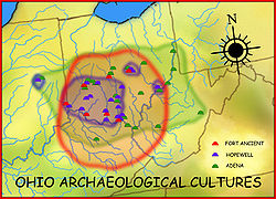
Kentucky Sites West Virginia Sites Indiana Sites Mounds State Park ·Related topics · Ancient Monuments of the Mississippi Valley · burial mound · Eastern Agricultural Complex · Hopewell tradition  Hopewellian peoples
Woodland period · List of Hopewell sites · Mound builder (people) · List of archaeological periods (North America) Ohio Hopewell Beam Farm · Benham Mound · Cary Village Site · Cedar-Bank Works · Dunns Pond Mound · Ellis Mounds · Ety Enclosure · Ety Habitation Site · Fort Ancient · Fortified Hill Works · Great Hopewell Road · High Banks Works · Hopeton Earthworks · Hopewell Culture National Historical Park · Indian Mound Cemetery · Keiter Mound · Marietta Earthworks · Moorehead Circle · Mound of Pipes · Nettle Lake Mound Group · Newark Earthworks · Oak Mounds · Perin Village Site · Portsmouth Earthworks · Seip Earthworks and Dill Mounds District · Shawnee Lookout · Tremper Mound and Works · Williamson Mound Archeological District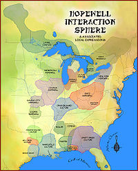
Crab Orchard culture Goodall Focus Goodall Site · Norton Mound GroupHavana Hopewell culture Kansas City Hopewell Marksville culture Miller culture Point Peninsula Complex Swift Creek culture Etowah Indian Mounds · Leake Mounds · Kolomoki Mounds Historic Park · Miner's Creek site, · Nacoochee Mound · Swift Creek mound site · Yearwood siteOther Hopewellian peoples Armstrong culture · Copena culture · Fourche Maline culture · Laurel Complex · Saugeen Complex · Old Stone Fort (Tennessee)Exotic trade items Related topics · Ancient Monuments of the Mississippi Valley · Black drink · burial mound · Calumet (pipe) · Effigy mound · Hopewell pottery · Horned Serpent · Eastern Agricultural Complex · Underwater panther Protected Areas of Indiana National Park Service National Forests National Wildlife Refuges National Natural Landmarks State Parks Brown County • Chain O'Lakes • Charlestown • Clifty Falls • Falls of the Ohio • Fort Harrison • Harmonie • Indiana Dunes • Lincoln • McCormick's Creek • Mounds • O'Bannon Woods • Ouabache • Pokagon • Potato Creek • Prophetstown • Shades • Shakamak • Spring Mill • Summit Lake • Tippecanoe River • Turkey Run • Versailles • White River • Whitewater Memorial
State Forests and State Recreation Areas Clark • Deam Lake • Ferdinand • Greene-Sullivan • Harrison-Crawford • Jackson-Washington • Martin • Morgan-Monroe • Owen-Putnam • Pike • Salamonie River • Selmier • Starve-Hollow • Yellowwood
National Historic Landmarks National Register of Historic Places Indiana Department of Natural Resources Categories:- Mounds in the United States
- Adena culture
- Indianapolis-Anderson-Columbus geography stubs
- Hopewellian peoples
- Native American history of Indiana
- Archaeological sites in Indiana
- Indiana state parks
- National Register of Historic Places in Madison County, Indiana
- Protected areas established in 1973
- Anderson, Indiana
- Protected areas of Madison County, Indiana


Wikimedia Foundation. 2010.